| Cosmic View: The Universe in 40 Jumps by Kees Boeke (1957) |
page 12 |
|
| TOP Flaps 1 2 3 4 5 6 7 8 9 10 11 12 13 14 15 16 17 18 19 20 21 22 23 24 25 26 27 28 29 30 31 32 33 34 35 36 37 38 39 40 41 42 43 44 45 46 47 48 |
| Powers of ten: 1 2 3 4 5 6 7 8 9 10 11 12 13 14 15 16 17 18 19 20 21 22 23 24 25 26 27 <> 1 0 -1 -2 -3 -4 -5 -6 -7 -8 -9 -10 -11 -12 -13 |
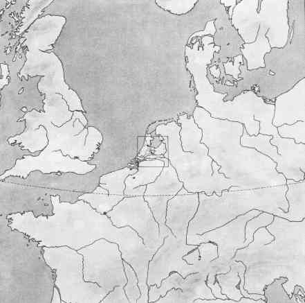 | |||
| 7. |
Whereas picture 5 gave us the villages of a local district, and #6 the towns of
a country, this 7th drawing covers part of a continent - Western Europe -
and shows a number of its countries. Actually 15 different countries are wholly
or partly visible, as well as 10 of their capitals and a number of rivers, too
many to mention by name. The map further shows three seas - the North Sea,
the Baltic, and the Adriatic - and a portion of one of the oceans, the Atlantic.
As a square 1500 kilometers on a side is covered, the spherical shape of the
earth becomes visible; one of the parallels of latitude is drawn to demonstrate
this, but the curvature is still so slight that the map can still be thought of as flat.
It will need one more jump to reveal it as part of the surface of a sphere.
| ||
|
This content is from Kees Boeke's book, Cosmic View: The Universe
in 40 Jumps. It has been placed online without permission. Copyright (C) 1957 by Kees Boeke. All rights reserved. No part of this book may be reprinted, or reproduced or utilized in any form or by any electronic, mechanical or other means, now known or hereafter invented, including photo-copying and recording, or in any information storage and retrieval system, without permission. |