There are some hints below...
| looking Northward | ||
| looking Westward |
 |
looking Eastward |
| looking Southward |
There are some hints below...
| looking Northward | ||
| looking Westward |
|
looking Eastward |
| looking Southward |
| US Canada Hudson Bay Alaska | northern New England Canada Baffin Bay Greenland Arctic ocean | Newfoundland northern Atlantic Europe |
| US Pacific ocean | Asia Australia Antartica | Africa Atlantic ocean |
| US Gulf of Mexico Central America Pacific ocean | South America Carribean Atlantic ocean | Atlantic ocean |
What I like about this concept is that it contributes concreteness. With a globe or a map, one has an abstraction, and thus must keep making the transition "this is a representation of a real thing which is actually someplace else". As opposed to the directness of pointing and knowing "it is right over there, even if I can't see it from where I am now".
A nice concept: "Use your head [...] imagine your own head as a model Earth. If you're in the northern hemisphere, imagine North America on the right side of your forehead and South America sitting on your left cheek, dripping off your chin like a kind of continental goatee. Africa is hung over your left ear, and Eurasia forms a skullcap across the back of your head. The right side of your head is almost all Pacific Ocean except for Australia, located "down under" and behind your right ear. [Turning your head, bring...] locations on your model Earth around to experience sunrise, noon, sunset, and midnight. Where is the Sun rising while your part of the Earth sees it setting? Which part of the world is sleeping while you eat your lunch?" ["Getting a Global Sense" by LuAnn Dahlman, in Mercury, May-June 1998 p6]
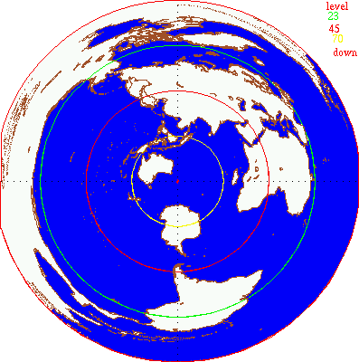
Drawing the "view from Boston" map:
  The map is the World Coast Line data from USGS's Coastline Extractor.
  I hacked a quick perl script,
  and plotted the result as points with gnuplot (using these settings).
  Then quickly colorized it by hand.

Doables:
    This has been a quick hack, and there is much which might be done.
    But I think I'll wait to see the response.

  Discuss slope (eg SouthAm slanting down and away)
      and orientation (eg, Africa).
  Dynamically draw maps for arbitrary locations.
  Perhaps using the Host name to Latitude/Longitude converter.
  Add some samples, perhaps a San Francisco and a mid-Europe.
  Do a second pass through the text.
  Elaborate on pointing, spatial memory, etc, etc.
  Add notes on deciphering the Boston map.
  A bowl diagram?  A earth crosssection, what does it mean to look down, diagram?
  A stickfigure pointing down to illustrate the concept.
  Perhaps color the continents and add a key for easy identification.
  What else?

History:
 1998.Sep.17 Added `Use your head' quote.
 1998.Feb.25 Created web page.
             I got the idea last week when about to hacksaw a globe
	     to create a Boston-centered hemispherical half-globe.